Public boat ramps on Lake of the Ozarks: a complete guide
Boaters at Lake of the Ozarks don't navigate by addresses. They use mile markers, measured from Bagnell Dam (MM 0) up the main Osage channel 92 miles to the Truman Dam tailwater. Tell someone to meet you at the 19-mile-marker, and they know exactly where to be.
This guide walks every public boat ramp on the lake the way locals navigate, by region and mile marker. It pins down the things that actually matter when you trailer down: who runs each ramp, what the fee is (or isn't), and which ones close when the lake drops.

Lake of the Ozarks at a glance
- Surface area: 54,000 acres at full pool
- Length: 92 miles, Bagnell Dam to Truman tailwater
- Shoreline: 1,150 miles
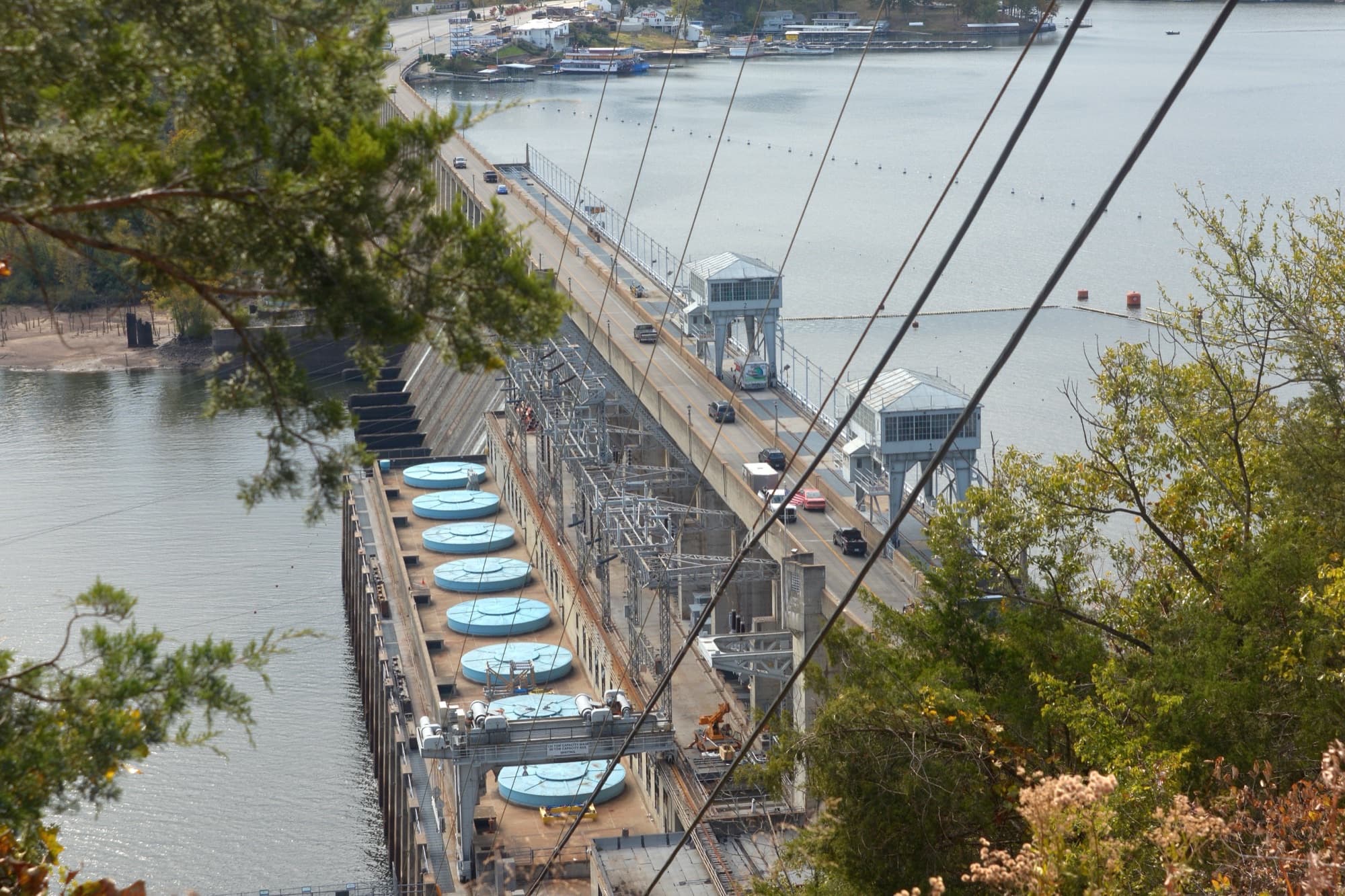
- Owner / operator: Ameren Missouri (private hydroelectric, FERC-licensed; license renewed 2011)
- Counties: Camden, Miller, Morgan, Benton
- Major arms: Niangua, Gravois, Glaize. Each has its own mile-marker subsystem branching from the main channel.
Unlike most large reservoirs in America, Lake of the Ozarks isn't a federal lake. It's privately owned by Ameren Missouri, the utility that runs Bagnell Dam under a FERC license last renewed in 2011. Truman Lake just upstream is the Corps of Engineers reservoir; this lake is something different. The practical effect: no single agency runs the public ramps. Access is a patchwork of Missouri State Parks launches and Missouri Department of Conservation accesses spread across the four counties that ring the lake.
How mile markers actually work here
The main Osage channel gets the headline numbering. MM 0 is at Bagnell Dam at the east end. The numbers go up as you head west toward Truman.
The big arms each get their own subsystem. The Gravois Arm, branching north into Morgan County, has its own MM 0 at the mouth and counts up the arm. Same on the Niangua, same on the Glaize. So when someone says “Coffman Beach is at MM 2.6,” they mean 2.6 miles up the Gravois Arm, not 2.6 miles up the main channel. This trips up out-of-state boaters constantly.
Most regulars run Navionics or a similar app on a phone to keep arm boundaries and mile markers straight. If you go that route, a waterproof phone pouch is cheap insurance. Phones go overboard at this lake more than people admit.
Lake of the Ozarks State Park: the four state park launches
Lake of the Ozarks State Park is the largest in Missouri, wraps the Camden County shoreline between Linn Creek and Osage Beach, and runs three primary paid ramps plus one free ramp on the Glaize Arm. Daily launch fee at the three primary ramps is $5 for vessels up to 30 feet and $10 for vessels over 30 feet; annual permits are $75 and $85. Campers with a current park camping permit launch free at any park ramp.
Grand Glaize Beach (4 lanes, year-round)
Sometimes labeled “Public Beach #2” or PB2 in older signage and maps. Four-lane paved ramp off Highway 54. With Pa He Tsi closing four months a year, Grand Glaize is the park's busiest year-round launch.
Pa He Tsi (4 lanes, March–October)
Four-lane ramp at 711 Public Road in Osage Beach. Same fee structure as Grand Glaize. Open March through October only. Even during the open season, the launch shuts when the lake drops below 658.5 ft. Check Ameren's current pool elevation before relying on this one in a low-water year.
Public Beach #1 (2 lanes, year-round)
Two-lane paved ramp, smaller capacity than Grand Glaize but reliable and open year-round. Same fee structure.
McCubbin's Point (Glaize Arm MM 8, free)
It's on the Glaize Arm at MM 8, inside Lake of the Ozarks State Park, but it doesn't show up on the main park signage so a lot of visitors miss it. There's an attached campground, the launch is free, and it's the right answer when the fee ramps are full and you don't want to pay.
Missouri Department of Conservation accesses (free, on the lake)
MDC accesses are free public-access points. General use is 4 a.m. to 10 p.m.; launching, landing, fishing, and camping (where permitted) are allowed 24 hours. All MDC contact for the lake-region accesses goes through (573) 346-2210.
Larry R. Gale Access (Camden, Niangua Arm)
The standout MDC access on the lake: a 2-lane lighted ramp built for 24-hour launching, courtesy dock, 50-vehicle parking, ADA-accessible privies, fishing dock, and walkways. 192.5 acres total, opened to the public in 1991. From Camdenton, four miles west on Highway 54 to Koehler Road. Free.
Shawnee Bend Access (Camden, MM 10.9 Osage Arm)
Near Sunrise Beach. 6.5-acre site with a boat ramp, accessible multipurpose dock, and a courtesy dock. From Highway 5 south of Sunrise Beach, take Route F about a mile, then Route TT northeast roughly 2.3 miles. Free.
Coffman Beach Access (Morgan, MM 2.6 Gravois Arm)
Near Rocky Mount, southwest of Eldon. 7.9 acres. Boat ramp, fishing dock, picnic tables. From Eldon: Route Y west to Lake Road Y-20. Free.
Gravois Mills Access (Morgan, MM 10.10 Gravois Arm)
In the town of Gravois Mills, with a 30-foot-wide concrete ramp. Walking distance to a grocery, post office, and a couple of restaurants if you want a between-trip lunch break. From Gravois Mills, take Highway 5 to the northern city limits and watch for the brown access sign on the east. Free.
Brown Bend Access (Camden, MM 61.5 Osage Arm, upper lake)
20-foot concrete ramp with a gradual slope. Reach it via Climax Springs and Route DD, a scenic drive that's an event in itself. Quietest of the MDC accesses on the lower-to-mid lake by a wide margin. Free.
Wigwam School Access (Morgan, MM 66.20 Osage Arm, upper lake)
The biggest MDC access on the upper lake by parking capacity: a two-lane paved ramp with turnaround, a lakefront weigh-in station, and 89 vehicle-and-trailer parking slots, among the highest-capacity public ramps on the entire lake. Public restrooms, handicapped parking. The 78-acre area opened in 2009 and is named after a 1905 schoolhouse that was submerged when the lake filled in the 1930s. From Laurie, take Highway 135 west about 10 miles, then Ivy Bend Road south to Webb Loop and west to the area entrance. Free.
A note about Bagnell Dam Access (it's below the dam, not on the lake)
There's a separate MDC access called Bagnell Dam Accessthat's frequently confused for a lake ramp because of its name. It isn't. It sits at the base of Bagnell Dam on the Osage River, the downstream side of the dam, not the impounded lake. It's a 60-foot-wide concrete ramp with two launching lanes and parking for 50 vehicles, free and MDC-operated. If you want to fish the tailwater or float the Osage downstream, this is your put-in. Don't trailer here expecting to get on Lake of the Ozarks.
Where to launch when the popular ramps are full
By late morning on a holiday Saturday, the parking at Grand Glaize Beach, Public Beach #1, and Larry R. Gale is gone. The lake's most-used launches are also its most-known. Quieter alternatives, by region:
- Lower lake / Camden side, free: McCubbin's Pointon the Glaize Arm at MM 8. State park ramp, free, often overlooked because it isn't on the main park signage.
- Niangua Arm, free: Larry R. Galeis the headline access. If it's full, the upper Niangua has additional access points worth scouting.
- Gravois Arm, free: Coffman Beach (MM 2.6) before you reach the resort traffic; Gravois Mills(MM 10.10) if you don't mind launching in town.
- Upper lake, free: Brown Bend (MM 61.5) and Wigwam School (MM 66.20). Both are 30+ minutes farther from the dam than the popular ramps. Wigwam in particular has 89 trailer slots. Functionally no parking problem here, ever.
About the upper lake (Benton County)
Lake of the Ozarks tapers into Truman Dam tailwater up around the Benton County line. The “Warsaw on the lake” cluster of public ramps that show up in regional listings are mostly Truman Lakeramps (a separate Corps of Engineers reservoir upstream of Truman Dam), not Lake of the Ozarks ramps. If you're targeting upper-lake water on Lake of the Ozarks itself, Wigwam School Access (Morgan County, MM 66.20) is the deepest agency-verified public launch heading west, with Brown Bend(Camden, MM 61.5) the next-closest. Beyond Wigwam you're in mixed territory and should check directly with MDC or the Corps for current Truman/Osage-arm openings.
What to know before you trailer down
- Lake levels move.Bagnell Dam releases are scheduled by Ameren and can shift pool elevation enough to matter for shallow ramps. Check current elevation before relying on Pa He Tsi (closes below 658.5 ft) or any of the shallow-cove launches.
- Mile markers on arms ≠ main channel.A ramp at “Gravois MM 10” is up the Gravois Arm, not on the main channel near Linn Creek. Confirm the arm before plotting your drive.
- The lower main channel gets rough.Below MM 10, a windy summer afternoon can build serious chop, especially when weekend traffic stacks up. New boaters routinely underestimate it.
- No federal-lake rules apply.Shoreline regulations come from Ameren's FERC license, not Corps of Engineers policy. If you've boated Truman Lake, the rules here are different.
What first-timers forget at the ramp
After running a directory of 47,000+ public ramps long enough, the same items show up in “left at the launch” posts week after week. Four worth keeping a spare of in the truck:
- Trailer drain plug· Amazon ↗ (~$7). The single most-forgotten item, period. Also the one that ends a trip fastest.
- Kill-switch lanyard· Amazon ↗ (~$8). Federally required on most boats since April 2021. Easy to lose, easy to replace.
- Spare 15-ft dock line· Amazon ↗ (~$15). One frayed line at a busy ramp ruins a morning.
- USCG-approved PFDs· Amazon ↗ (~$72). Sized for everyone aboard. Park and MDC ramps don’t loan these out.
As an Amazon Associate, BoatRampMap.com earns from qualifying purchases. Commissions help keep the directory free.
Every public ramp on Lake of the Ozarks
The 13 agency-verified public launches are mapped below and listed in the table. 29additional access points marked by OpenStreetMap (mostly unnamed coordinates without verified operators) appear on the map but aren't in the table. Click any ramp on the map or table to see GPS coordinates, directions, and full details.
| Ramp | Location | Operator |
|---|---|---|
| Public Beach #1 | Public Beach #1, state park (Camden) | Missouri State Parks |
| Grand Glaize Beach | Grand Glaize Beach, state park (Camden) | Missouri State Parks |
| Brown Bend Access | Osage Arm, MM 61.5 (Camden, upper lake) | MDC |
| Lake of the Ozarks Recreation Area | Camden County | Public access |
| Larry R. Gale Access | Niangua Arm (Camden) | MDC |
| Linn Creek | Linn Creek arm (Camden) | Public access |
| McCubbins Point | Glaize Arm, MM 8 (Camden, in state park) | Missouri State Parks |
| Pa He Tsi | State Park, Glaize area (Camden) | Missouri State Parks |
| Shawnee Bend Access | Osage Arm, MM 10.9 (Camden) | MDC |
| Bluebird Road | Lower lake (Miller) | MDC |
| Coffman Beach Access | Gravois Arm, MM 2.6 (Morgan) | MDC |
| Gravois Mills Access | Gravois Arm, MM 10.10 (Morgan) | MDC |
| Wigwam School Access | Osage Arm, MM 66.20 (Morgan, upper lake) | MDC |
Plus 29 additional access points marked by OpenStreetMap, scattered across the lake. They appear on the map above; for the comprehensive list, see the Lake of the Ozarks waterbody page.
Methodology and sources
Ramp inventory comes from our database of 46,900+ public ramps, filtered to records on Lake of the Ozarks and its named arms (Niangua, Gravois, Glaize, Golden Goose Cove) across the four Missouri counties that touch the lake. We don't list private docks, HOA-only launches, or resort marinas; only true public-access launches. Named ramps in the table come from USGS, MDC, and Missouri State Parks feeds. Additional dots on the map are sourced from OpenStreetMap; their coordinates are valid but operator and amenity details aren't independently verified, so we don't name them in the table.
State park fees and ramp configurations were checked against Missouri State Parks. MDC access details came from individual mdc.mo.gov access pages. Lake stats (surface area, shoreline, ownership, FERC license history) were verified against Wikipedia and Ameren Missouri. Last verified April 2026.
Frequently asked questions
Is Lake of the Ozarks a federal lake?
No. It's a privately owned hydroelectric reservoir operated by Ameren Missouri under a FERC license that was last renewed in 2011. Truman Lake just upstream is the Corps of Engineers reservoir.
What is the cheapest way to launch on Lake of the Ozarks?
The Missouri Department of Conservation accesses are all free: Larry R. Gale, Shawnee Bend, Coffman Beach, Gravois Mills, Brown Bend, and Wigwam School. McCubbin's Point inside the state park is also free.
Where are the boat ramps in Lake of the Ozarks State Park?
Three primary paid ramps (Grand Glaize Beach, Pa He Tsi, Public Beach #1) and one free ramp (McCubbin's Point on the Glaize Arm at MM 8). Daily launch fee at the three primary ramps is $5 for vessels up to 30 ft and $10 for larger vessels.
Can I launch a boat on Lake of the Ozarks for free?
Yes. Every Missouri Department of Conservation access on the lake is free, plus McCubbin's Point in the state park. The most-developed free ramp is Larry R. Gale Access on the Niangua Arm, which has a lighted 2-lane ramp open 24 hours and ADA-accessible facilities. Browse our free boat ramps in Missouri directory for confirmed no-fee launches statewide.
Does Pa He Tsi really close in low water?
Yes. The launch closes when lake elevation drops below 658.5 ft. It's also closed seasonally from November through February.
What is the busiest ramp on Lake of the Ozarks?
The state park's Grand Glaize Beach is generally the highest-volume public ramp on the lake, followed by Larry R. Gale Access on the Niangua Arm and Public Beach #1.
What is the difference between Lake of the Ozarks and Truman Lake?
Two separate reservoirs separated by Truman Dam. Lake of the Ozarks is the lower lake, privately owned by Ameren Missouri. Truman Lake sits upstream of Truman Dam and is a Corps of Engineers reservoir, built primarily for flood control.
See also: 10 Best States for Boat Ramp Access, Ranked · Every Lake of the Ozarks ramp on the map · All boat ramps in Missouri